Istria County is the westernmost county of Croatia which includes the biggest part of the Istrian peninsula 2,820 km2 out of 3,160 km2. The county administrative centre is Pazin (9,227 inhabitants) while economic centre is Pula (58,594 inhabitants). Other major cities in the county are Poreč, Rovinj, Labin, Novigrad, Umag, Buzet, Buje and Vodnjan. About 70,7 % of the population live in these 10 urban areas. According to 2011 census, the total population of Istria County is 208,055 or 4,85 percent of the population in Croatia.

Map of the Istrian peninsula
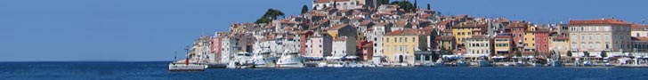
Blue seas, white stone and the green interior make up the colour scheme of Istria. The blueness of its shoreline is contrasted by the lush greenery of its interior and the small, hilltop towns like Labin, Hum (the smallest town in the world), Roč and Motovun. Istria is known as the Terra Magica with a cultural arboretum whose heritage comes from the Histrians, Celts, Romans, Byzantines, Slavs, Venetians and the Austro-Hungarians. It is the largest green oasis of the North Adriatic.

Town of Motovun
The coast and the islands of Istria are covered with pine woods and easily recognizable green macchia. A smaller part of Istria also belongs to the Primorje-Gorski Kotar County of Croatia. The westernmost point is at Savudrija, while the southernmost is near Premantura, on the local promontory Kamenjak. The highest point is Vojak on the Učka mountain (1,401 m above sea level), while another range of mountains is Ćićarija. There are so called White, Grey and Red Istria. White Istria is around the mountain peaks, Grey Istria is the fertile inner land, while Red Istria is the blood-red painted land of terra rossa near the coastline. Sites such as the Baredine cave near Poreč, the underground river Pazinčica and the Pazin cavenear Pazin are popular geologic attractions. Other interesting localities in Istria are the Wood near Motovun and the Lim Bay and valley between Rovinj and Vrsar. The Zlatni rt (Golden Cape) Park Forest is the most significant park area on the western Adriatic coast. This is the oldest protected site in Istria, having a high horticultural value. It is an inevitable destination for enjoying a walk or biking in nature and it is easily accessible. It is only 15 minutes walk from the centre of Rovinj. The Palud Ornithological Reserve is situated only 10 km from Rovinj, near the Veštar campsite facility, it is easily accessible and defined by brackish wetlands with interesting vegetation, including several rare plant species. National park Brijuni is interesting as the habitat of about 680 plant species, also decorated by the most diverse vegetation and olive groves. It includes 14 islands that are located on a seven kilometres stretch between Pula and Rovinj. The longest river, the Mirna, is only 32 km long with its mouth near Novigrad. Other rivers that pass through Istria are the Dragonja River and Raša River. Agriculture and the production of ecological food, the olive gardens, and the production of quality wines, is the focus of the agriculture sector of istria.

NP Brijuni islands
The climate in Istria is Mediterranean, with the highest air temperature averaging 24 °C during August and the lowest averaging 5 °C in January. Summers are usually warm during the day and cooler near the evening. The lowest sea temperature is in March and ranges from 9,3°C to 11,1°C. The highest sea temperature is in August, from 23,3°C to 24,1°C. The salinity of the sea water is approximately 3.6 to 3.8 %.
The website The Joys of Traveling included Istria on the list of the ten best tourist destinations in 2012. Istria is described as the Tuscany of Croatia which exceeds, due to its beauty, many more expensive and better known Mediterranean destinations. It is to praise not only the natural beauty, but also the infrastructure, especially roads, some of which being narrow but well-maintained. While driving, every now and then something interesting can be seen.